Note that I try to keep this info up-to-date, but be sure to check the web links, and also check with these parks & locations to be 100% sure (I could be wrong, and sometimes their rules change...)
Info from a member of the RTP Kayak Flatwater Meetup ...
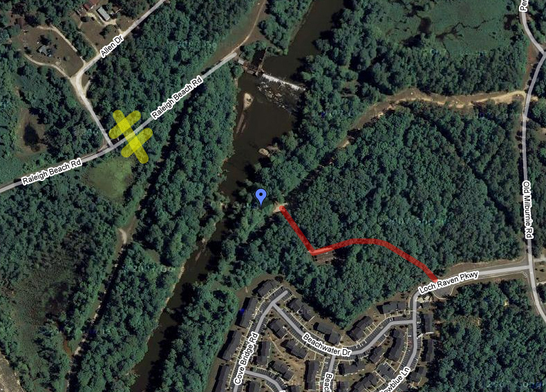
The area around the Milburnie Dam is a little confusing in terms of dam portage vs put-in / take-out. The Google Maps view of that whole area around the dam makes it look like the access road to the new put-in comes off of Milburnie Road (river left downstream of the dam) . Apparently that used to be the road or it was the road that was used to construct the area around the put in. But that road is now blocked by huge rocks. The real access road comes off Loch Raven Pkwy (just like it says on the Neuse River Canoe Trail web page) and is mostly hidden by trees. After you turn onto Loch Raven Pkwy you will see a sign that indicates where the access road is.
In the Google Map link below, the yellow bar with hashmarks is the gated road to the dam. The red line is the access road to the new put in.
(35.799637,-78.53891)
Google Satellite Map (put-in)
Info from froghollowoutdoors.com ... Length of Trip: 1 to 2 hours depending upon water levels and paddling speed. Stopping for lunch will lengthen the time for this trip. Put In: Milburnie Dam Access just off of Highway 64 east of Raleigh Take Out: Poole Road access, just east of Raleigh. River right, upstream side of bridge. Description: This is a short but nice stretch of the Neuse River. Good scenery and abundant wildlife make it hard to believe that this stretch of the Neuse is literally right next to Raleigh. It is possible to paddle a short distance up Crabtree Creek and soon after passing Crabtree Creek are some nice rock islands and a potential Class II rapid that make a very nice lunch stop.
